


How Drone Technology Is Changing Field Scouting in Agriculture
Key takeaways
- Drone field scouting images the whole field from above, so you see what’s between the spots you would have walked.
- Today’s drones can map emergence, crop stress, weeds, and stones. What you get depends on camera resolution, timing, and the software reading the images.
- A map only pays if you act on it. A TerraClear Rock Map pins every stone it detects with centimeter-level GPS and gives you a pick route.
- Drones expand scouting. They don’t replace walking the field, and Saskatchewan’s crops extension team says the same.
- Transport Canada rules apply. Drones 250 g and up must be registered, and the pilot needs an RPAS certificate.
Walking a field has always meant sampling it. You stop at a handful of spots, look closely at what’s in front of you, and make a call on the rest of the quarter from what you saw. Drone scouting changes the math. A drone flies the entire field, and software reads every image.
I run TerraClear’s aerial imaging program. In good weather our drone crews image more than 1,000 acres a day, and the reaction to a first map often sounds like what North Dakota farmer Michael Rostad said: “TerraClear is a game changer for picking rocks. Once your field has been mapped, anyone can go efficiently and confidently clear the field.”
This guide covers what drones can find in a field today, where they still fall short, and how a stone map turns into picking that gets done.
What is drone field scouting?
Drone field scouting is the use of an unmanned aircraft with a camera to photograph a field from above, then using software to turn those photos into a map of what’s on the ground. Depending on the camera and the software, that map can show emergence, stand gaps, stress, weeds, or stones.
The drone itself is the easy part. The work is in the imaging and the analysis: how sharp the photos are, when they’re taken, and whether the software can tell a stone from a dirt clod or a chunk of straw.
How is drone scouting different from walking a field?
The biggest difference is coverage. Iowa State University Extension tells scouts to walk a Z, W, or diamond pattern and look closely at 5 to 15 plants at each stop, at least 50 to 100 plants per field. That’s good practice, and it’s still a sample.
A drone covers every acre. K-State Research and Extension estimates a 150-acre field takes at least half a day to scout on foot and about 30 minutes by drone.
| Walking the field | Drone scouting | |
|---|---|---|
| Coverage | Sample stops along a route | Every acre imaged |
| Time for 150 acres | Half a day or more | About 30 minutes of flying (K-State) |
| What you can see | Detail at each stop | Patterns across the whole field |
| Record | Notes and memory | A georeferenced map you can reopen |
| Weak spots | The ground between stops | Things hidden under canopy or heavy straw |
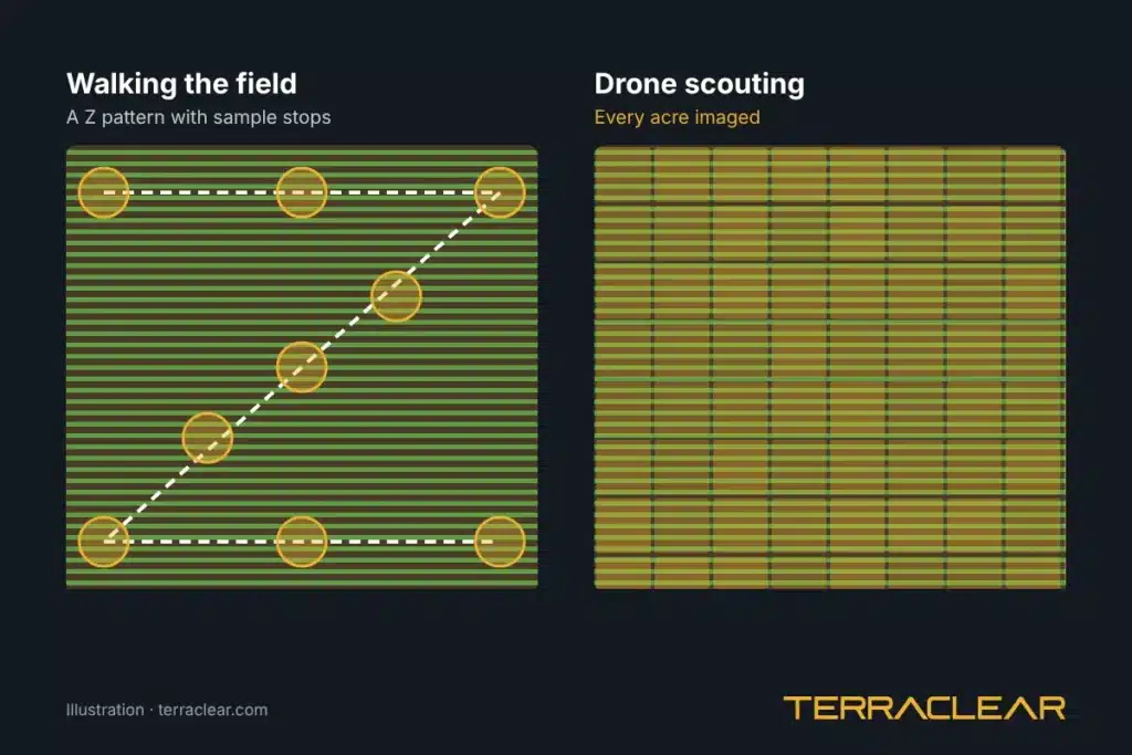
The two work best together. Saskatchewan Ministry of Agriculture crops extension specialist Davidson Ugheoke writes that drones help identify areas of stress or variability that need closer inspection, but they complement firsthand observation rather than replace it.
What can drones find in a field today?
On cereal, canola, and pulse ground, drones are useful for four jobs.
- Emergence and stand gaps. High-resolution colour imagery shows thin spots and uneven emergence that are hard to see from the ground.
- Crop stress. Multispectral cameras and indexes like NDVI show differences in growth, moisture stress, and nutrient issues before they’re obvious by eye.
- Weeds. Very high-resolution imagery paired with trained AI can pick out weed patches and, at high enough resolution, individual weeds.
- Stones. The same approach finds stones across a whole field, including in stubble, residue, and emerged crop. TerraClear Rock Maps detect stones 8″ (20 cm) and larger.
How does a drone stone map get made?
Here’s how a TerraClear Rock Map goes from flight to field. Other services vary, but the steps are similar.
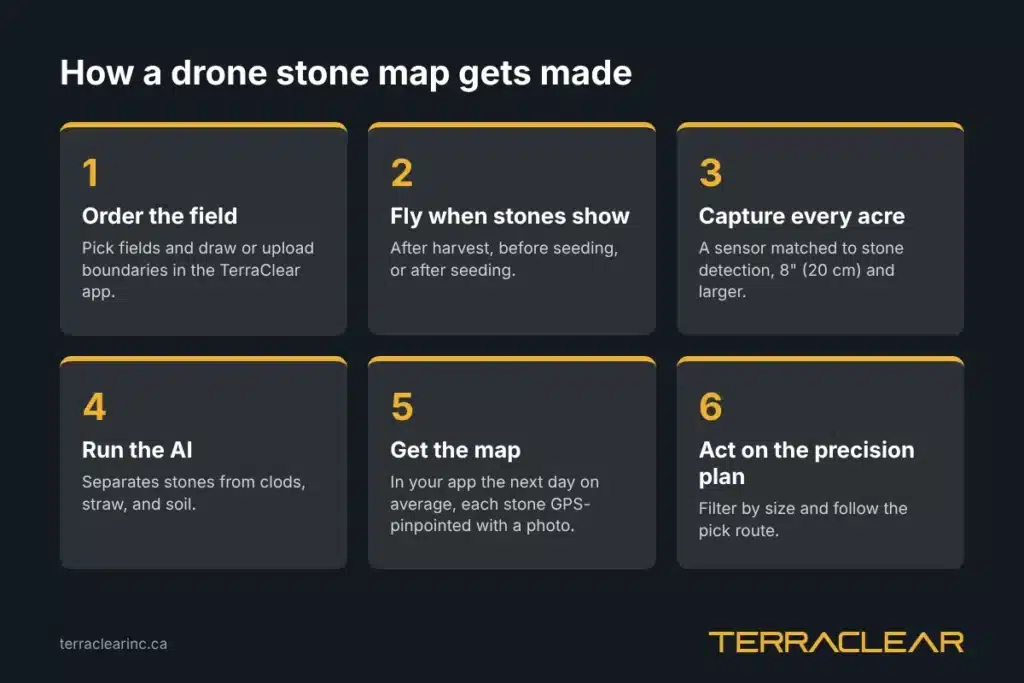
- Order the field. You pick fields and draw or upload boundaries in the TerraClear app.
- Fly when stones are visible. That can be after harvest, before seeding, or after seeding, as long as stones aren’t under snow or frozen ground.
- Capture every acre. The drone images the whole field with a sensor matched to stone detection. Stones 8″ (20 cm) and larger don’t need the extreme detail weed mapping does, so the flight is built around what you’re looking for.
- Run the AI. Models trained on rock images separate stones from clods, straw, and soil.
- Get the map. Maps land in your app the next day on average, with each stone tied to a precise GPS location and a photo.
- Act on the precision plan. Every map comes with a precision plan, meaning the action list you follow. For stones, that’s a filtered pick route.
How do farmers use a TerraClear Rock Map after the flight?
A TerraClear Rock Map turns stone picking from a search into a route. Each stone it detects, 8″ (20 cm) and larger, is pinned with centimeter-level GPS and a photo, so you can pull up to it and know what you’re looking for. Filter by size and pick the header-breakers first, follow an optimized pick route, and mark stones as picked so you and your crew can see what’s done.
Farmers using TerraClear Rock Maps find about 3x more stones and pick about 3x faster. Kyle O’Brien put it this way: “The map has just made rock picking for us so much easier because it takes, in my mind, it takes less time so we can get across more acres per day.”
TerraClear sells the map. You pick with your own crew and equipment, or we can refer you to an independent stone picking operator. Frost heave brings new stones up every spring, so plan on a fresh map rather than reusing last year’s. For more, see fall stone picking and GPS for stone picking.
[IMAGE: drone-stone-map-pick-route.webp | Alt text: Illustration of a TerraClear Rock Map showing stone pins and a pick route on a phone | Description: A TerraClear Rock Map pins each detected stone with centimeter-level GPS and a photo, then lays out a pick route.]
What can’t drone scouting do yet?
Drones have real limits, and you should know them before you buy a map or a drone.
- Someone still has to check the field. “You still need someone in the field to confirm what the imagery is showing,” says Deepak Joshi, precision ag specialist at K-State.
- Straw and canopy hide things. Heavy cereal stubble can hide smaller stones, and canopy can hide small weeds. Flying after straw settles, or before spring field work, helps.
- Weather sets the schedule. Wind, rain, snow cover, and low sun can all ground a flight, and battery swaps slow large acreages during tight windows.
- Transport Canada rules apply. Drones 250 g and up must be registered, and the pilot needs a Basic or Advanced RPAS certificate depending on the operation. Rules that took effect Nov. 4, 2025 added a Level 1 Complex certificate for some lower-risk flights beyond visual line of sight over sparsely populated areas.
Should you buy a drone or hire a mapping service?
Owning makes sense if you want to fly often and have someone with the time and the certificate to do it. Hiring makes sense if you’d rather get the map than manage the flights, registration, and image processing. TerraClear handles collection and delivery on a per-acre basis, so you order fields in the app and get maps back. Whoever you hire, pick a proven provider with real expertise. Ask how many acres they’ve mapped and which sensor they use for the job. TerraClear has mapped more than 1.5 million acres.
What comes after the drone?
Mapping at TerraClear moves to a mix of drone and TerraScout® over the next year. TerraScout is an autonomous ground scout built to capture imagery at 1.5mm ground sample distance with eight cameras and lighting for day or night work. It’s built to identify stones, weeds, and stand counts, with insect and disease detection planned for later. First deliveries are targeted for fall 2027, and you can reserve a TerraScout now.
Frequently asked questions
It depends on the job. Basic emergence and stress checks can use a consumer drone with an RGB or multispectral camera. Detecting individual stones takes very high resolution and trained AI, which is why most farmers hire a mapping service. TerraClear flies DJI Matrice RTK drones.
Accuracy depends on image resolution, flight timing, and the software. TerraClear uses a sensor matched to stone detection and ties every stone it detects to a precise GPS location. No method finds every stone, so plan on checking the field as you pick.
TerraClear delivers maps the next day on average after the flight.
If the drone weighs 250 g or more, it must be registered with Transport Canada and the pilot needs an RPAS pilot certificate. If you hire a service, the service carries those requirements.
Yes. TerraClear Rock Maps work in stubble, residue, and emerged crop as long as stones are visible from the air.
TerraClear Rock Maps have an MSRP of $5.50 CAD per acre mapped, and seasonal discounts are available. See current pricing or check the TerraClear Mobile App.
Talk to a TerraClear rep
Tell us about your fields and we’ll help you figure out when to map and which fields to start with. Fill out the form below or order maps in the TerraClear app.